
WES Artificial Intelligence - WES

WES Artificial Intelligence (WES-AI)
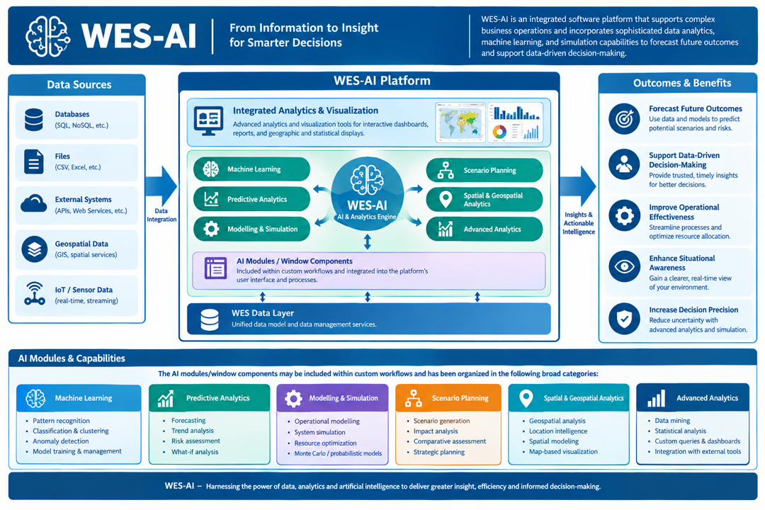
Provides artificial intelligence and the integration of advanced data analytics / visualization tools is essential. Used for modeling and simulation, predictive analytics, scenario planning, and visualization to enhance the system’s operational effectiveness, situational awareness, and decision-making precision.
Compusult’s WES-AI refers to an integrated software platform that supports complex business operations and incorporate sophisticated data analytics, machine learning, and simulation capabilities to forecast future outcomes and support data-driven decision-making.
It also includes the integration of advanced data analytics and visualization tools. This component may be used for modelling and simulation, predictive analytics, scenario planning, and visualization to enhance the system’s operational effectiveness, situational awareness, and decision-making precision.
The AI modules/window components may be included within custom workflows and has been organized in the following broad categories:
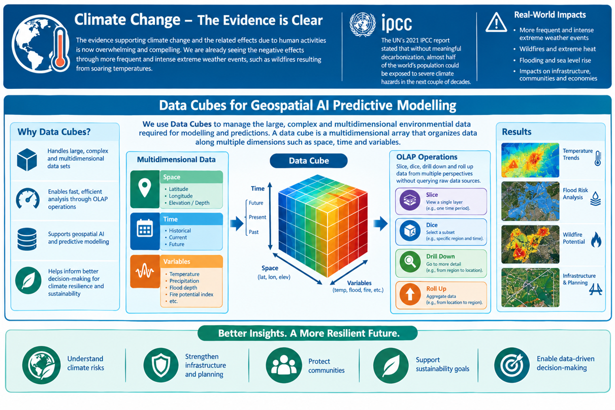
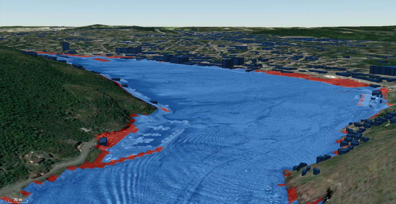
The evidence supporting climate change and the related effects due to human activities is now overwhelming and compelling. We are already seeing the negative effects of climate change through an increase in extreme weather events and calamities, such as wildfires resulting from soaring temperatures. The United Nations’ 2021 Intergovernmental Panel on Climate Change (IPCC) report stated that without meaningful decarbonization, almost half of the world’s population could be exposed to severe climate hazards in the next couple of decades. Analysis of infrastructure and planning are key to any mitigation efforts.
In order to facilitate geospatial AI predictive modelling, we have adopted the use of Data Cubes. It is a core component we utilize for managing the large, complex, and multidimensional environmental data required for modelling and predictions. A data cube is essentially a multidimensional array that organizes data along various dimensions, such as space (latitude, longitude, elevation/depth), time, and different variables (e.g., temperature, flood depth, fire potential index).
This structure is specifically designed to facilitate efficient multidimensional data analysis through Online Analytical Processing (OLAP) operations, which allows users and analytical models to quickly "slice and dice," drill down, and roll up data from multiple perspectives without having to query the original, raw data sources.
Beyond Basic Reporting
The MPS system moves beyond basic reporting to help enterprises anticipate trends, optimize processes, and manage risks.
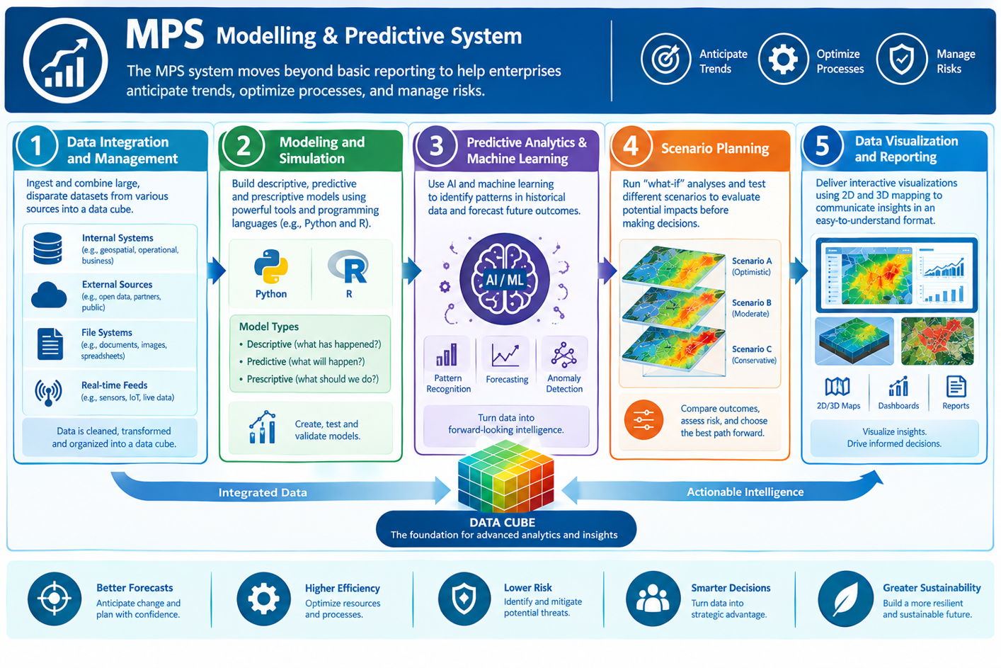
Some of the key features include:
Data Integration and Management
Modeling and Simulation
Predictive Analytics & Machine Learning
Scenario Planning
Data Visualization and Reporting
From Earth Observation
To Real-World Impact.
The following diagram provides a high-level overview of how data cubes were created from Copernicus Programmme. Copernicus is the Earth observation component of the European Union’s Space programme, looking at the planet and its environment to benefit all European citizens. It offers information services that draw from satellite Earth Observation and in-situ (non-space) data.
Vast amounts of global data from satellites and ground-based, airborne, and seaborne measurement systems provide information to help service providers, public authorities, and other international organisations improve European citizens' quality of life and beyond. The information services provided are free and openly accessible to users.
From plastics detection to drift modelling, we use this wealth of information to help our customers solve real world problems.
The ability to build descriptive, predictive, and prescriptive models allows simulation of marine disasters such as oil spills, ship collisions, or typhoon impacts. Simulations can test deployment strategies (e.g., where to send rescue vessels or drones) to maximize coverage and minimize response time. For example, running an ocean current and wind simulation can show how an oil spill might spread over time, allowing responders to plan containment booms more effectively. A machine learning model could predict potential distress signals before they occur by analyzing vessel speed, route deviation, and weather conditions.
Below are some examples on how WES uses multidimensional data for specific environmental monitoring and disaster management applications:
Sea Level Rise Modelling
Inland Flood Modelling and Response
For inland flood mapping, WES supports the integration of data from various sources to model water flow. Inland flood mapping utilizes shallow water equations; a set of hyperbolic partial differential equations used in fluid dynamics to model the flow of water from a lake or other inland source, enabling accurate flood prediction and management efforts.
Fire Prediction and Management
Arctic Ice Concentrations
From Earth Data
To Early Action
This diagram illustrates how Copernicus Programme models were utilized in providing forest fire index modeling and prediction.
In essence, data cubes transform vast, raw data streams into a structured, analysis-ready format that enables the rapid, interactive, and complex analyses necessary for effective disaster resilience and environmental management applications within WES.
AI Alerting uses actionable discrete AI-supported feature and binary data that is fine tuned to have the AI application make decisions on behalf of and in support of users and the associated stakeholders. This AI-supported feature and binary data include information such as ship AIS, NOAA ocean buoys, iceberg information, U.S, Federal Administration Aviation data, etc.
AI Alerting works upon actionable feature that is illustrated in the diagram.
Actionable datasets are ingested into the system in either real-time or near-real-time.
A flexible AI rule-based set of instructions is incorporated that the ingestion/harvesting sub-system utilizes as it takes new data into the system in order to enable the system to perform tasks that typically require human intelligence or interaction.
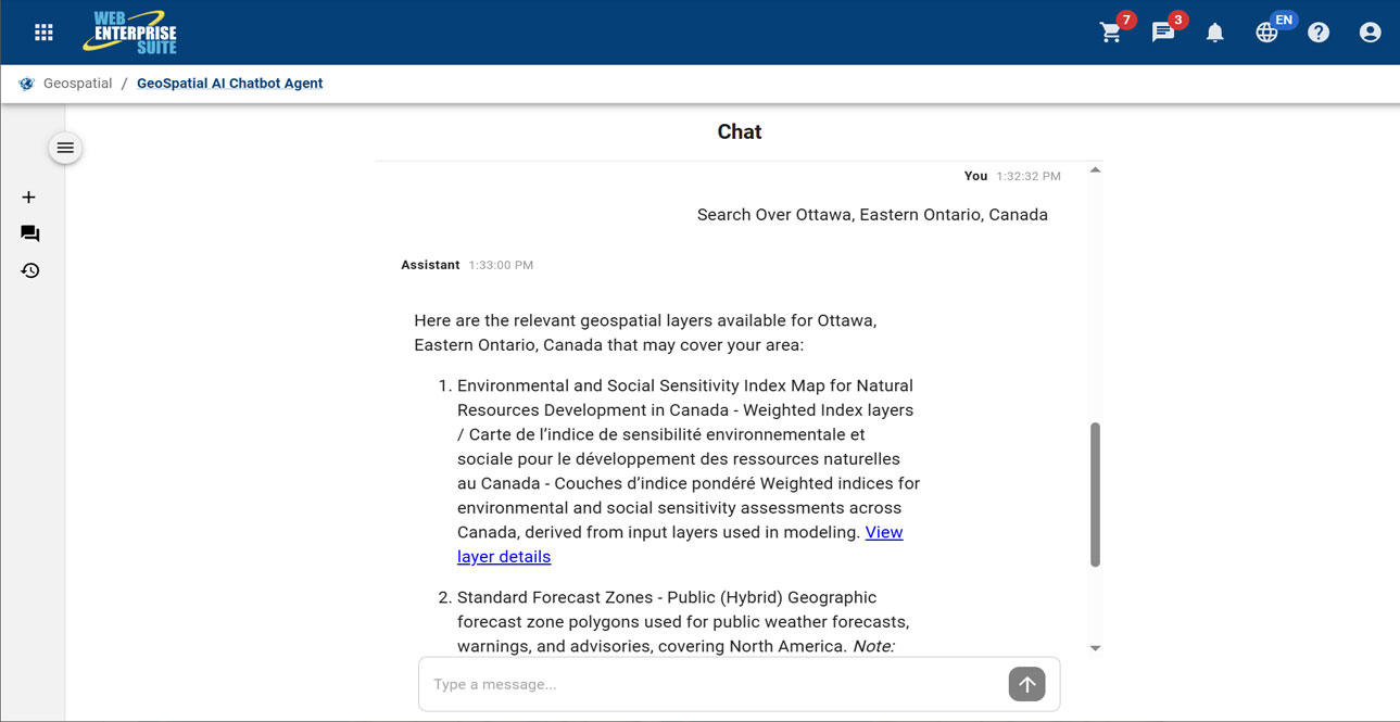
The Geospatial AI Chatbot is a microservices-based generative AI chatbot prototype with natural language processing capabilities to handle discovery of relevant information and content on behalf of a user.
This AI-powered conversational agent that uses natural language processing (NLP) to interact with geographic information systems (GIS), mapping data, and spatial analysis tools. It enables users to query, visualize, and analyze location-specific data such as satellite imagery, maps, or spatial datasets—through simple text prompts instead of complex coding or specialized software.
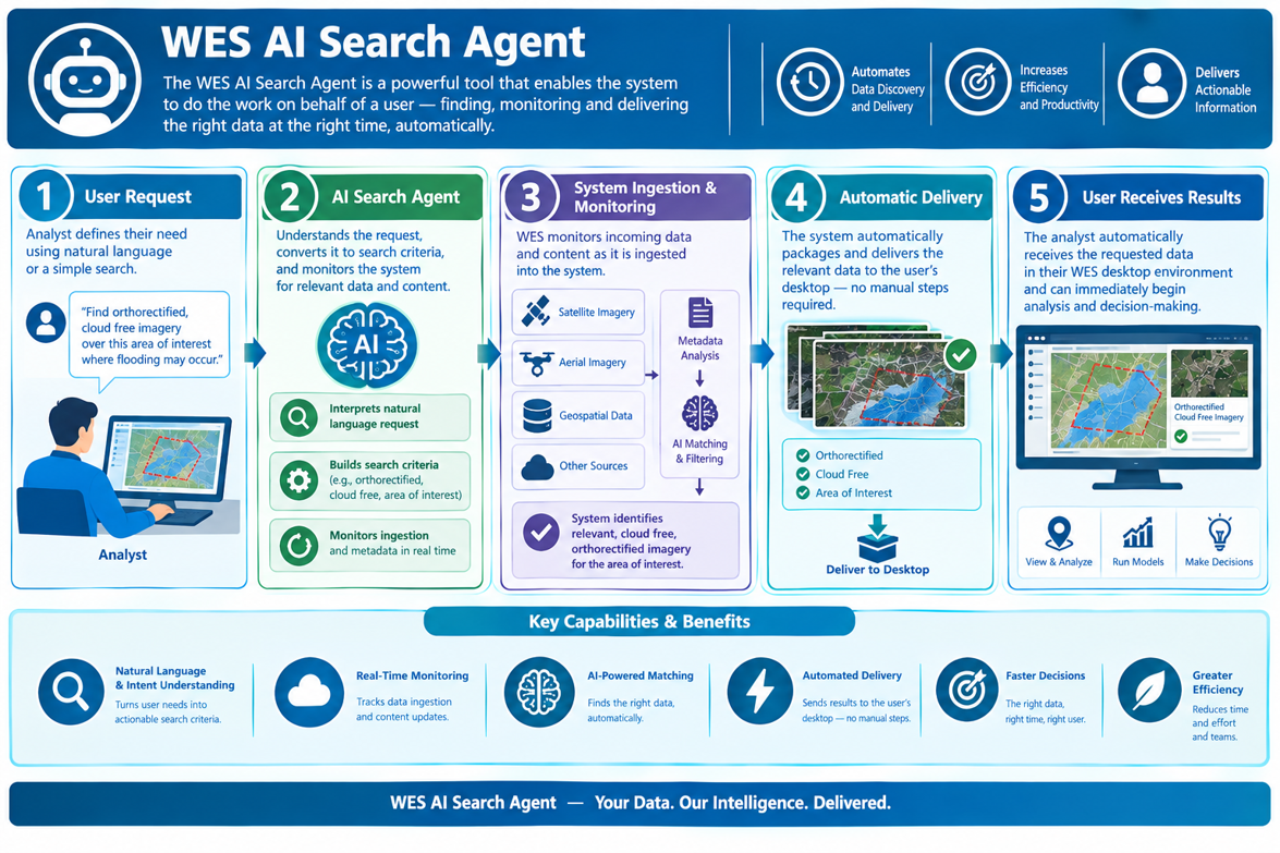
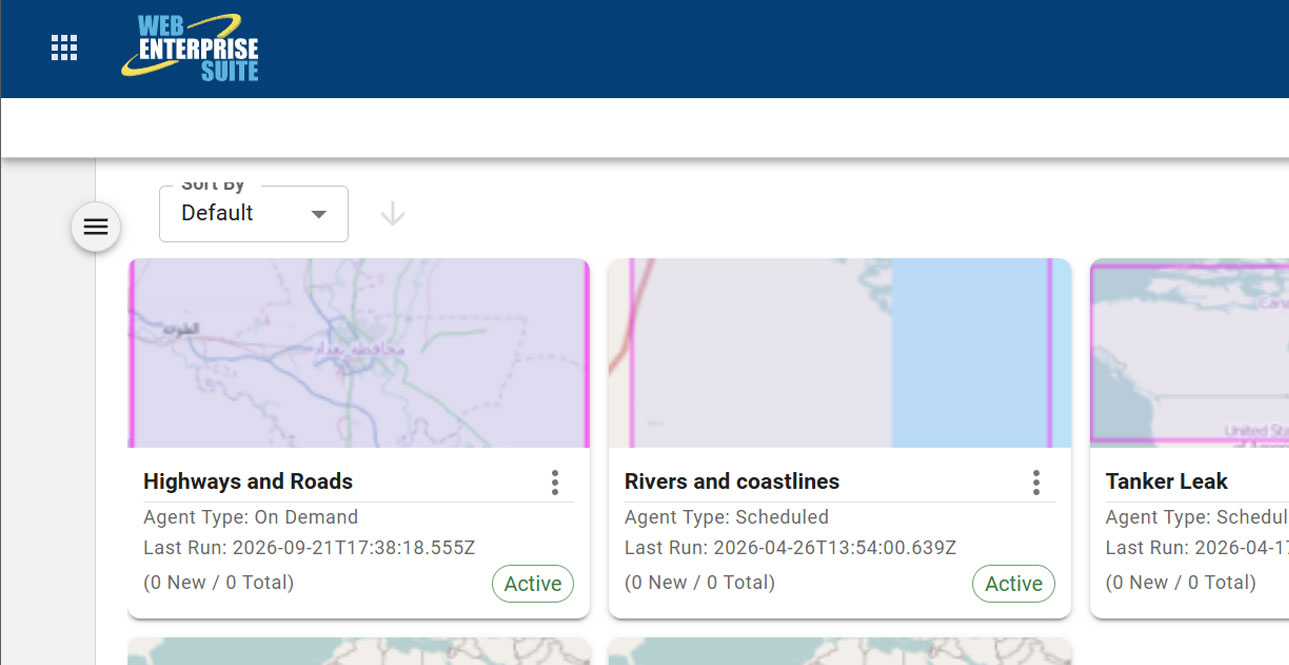
The WES AI Search Agent is a powerful tool that enables the system to do the work on behalf of a user. For example, if an analyst is interested in obtaining orthorectified cloud free imagery over a particular area of interest where flooding may occur.
The system will monitor the ingestion of information and content has it is entered in the system, will determine this user is interested in this data and automatically deliver it to the desktop without the user having to use the system.
WES Components
The tools and applications have been organized into the following components that are provided to organizations utilizing the capabilities:
WES Operations Centre
WES Geospatial
Enterprise data warehouse for storing, managing, and delivering geospatial, imagery, and business data at scale.
WES Analytics
WES AI
WES Administration
WES Operations Center
WES Geospatial
WES Analytics
WES AI
WES Administration
The AI modules/window components may be included within custom workflows and has been organized in the following broad categories:
Modelling and Predictive System (MPS)
The evidence supporting climate change and the related effects due to human activities is now overwhelming and compelling.

AI Alerting
An AI application make decisions on behalf of and in support of users and the associated stakeholders.
Geospatial AI Chatbot
A microservices-based generative AI chatbot prototype with natural language processing capabilities to handle discovery of relevant information and content on behalf of a user.
AI Search Agent
A powerful tool that enables the system to do the work on behalf of a user.
Request a Live Demo
Access our demo site to use a sandbox version of WES.


