
Web Enterprise Suite - The Total Geospatial Solution - WES



Transforms historical data into dashboards, charts, and reports for clear insights and informed decisions.

AI-powered analytics, modeling, and visualization for predictive insights, planning, and decision support.

Web Enterprise Suite
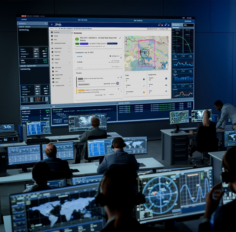
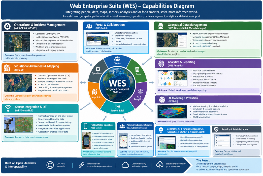
Web Enterprise Suite (WES) is a complete end-to-end multi-lingual geospatial platform/solution designed to provide organizations and agencies with the ability to manage and enable situational awareness required for the decision-making process. It has been specifically designed to enhance insight, understanding, recognition and context awareness of what is happening in multiple domains. WES capabilities include end-to-end geospatial operations, data management, emergency management and incident command, situational awareness, analytics, and AI platform.
WES capabilities at a glance include:
Situational Awareness - A Common Operational Picture (COP)/Situational Awareness Views that combines information from many sources and displays it on interactive 2D/3D maps.
Operations & Incident Management - Tools for emergency management, incident command, mission planning, resource coordination, and response operations.
Geospatial Data Management - Ingestion, storage, organization, management, and delivery of very large geospatial and non-geospatial datasets.
Data Discovery & Cataloguing - Metadata management, catalogues, search, discovery, publishing, and access to geospatial services and datasets.
Real-Time Sensor Integration - Connects cameras, IoT devices, environmental sensors, wearables, drones and other sources, including real-time monitoring and sensor tasking.
Field/Mobile Operations - Android/iOS/Windows capabilities for field personnel to collect, view and share geospatial information, including in disconnected environments.
Public/Crowdsourced Information - Allows members of the public or other external users to submit observations that feed into operational awareness.
Analytics & Reporting - Dashboards, charts, tables, reports, SQL querying, geospatial visualizations and no-code analytics through Apache Superset.
AI & Predictive Analytics - Modelling, simulation, machine learning, predictive analytics, scenario planning and 2D/3D visualization.
AI Alerting & Automation - Can ingest near-real-time information, apply rules/AI logic, trigger models and notify personnel when conditions warrant action.
Generative AI / Natural Language GIS - A prototype geospatial AI chatbot allows users to interact with GIS and spatial information using natural-language questions.
AI Data Discovery - AI agents can identify and deliver information relevant to an analyst's interests without requiring the analyst to manually search for it.
Security & Administration - User/group/role management, access control, auditing, logging, configuration, system health monitoring and installation/upgrade tools.
Web Enterprise Suite Capabilities
Web Enterprise Suite
The Total Geospatial Solution
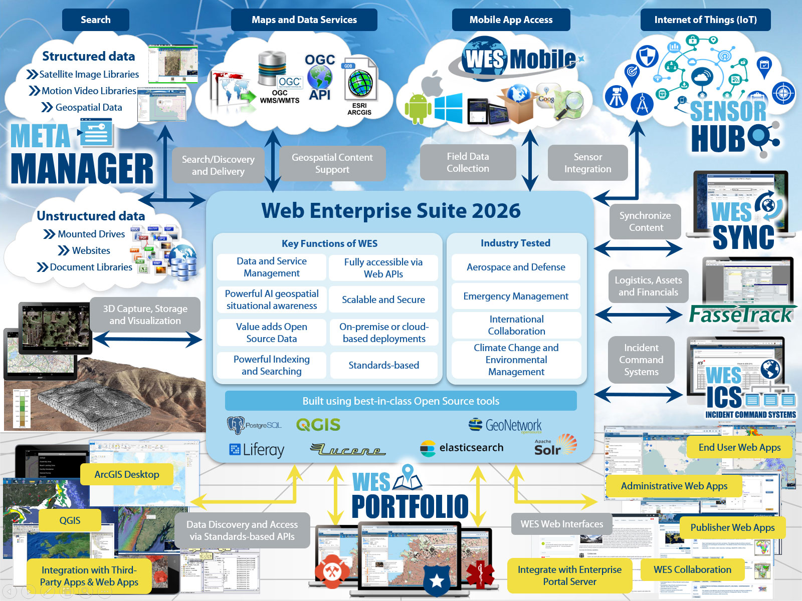
WES components are based on Open Geospatial Consortium (OGC) / International Organization for Standardization (ISO) and other interoperability specifications. They are compliant with many commercial/open-source tools and products, and allow seamless connections to the ever-expanding world of geospatial data sources and services.
WES Components
The tools and applications have been organized into the following categories that are provided to organizations utilizing the capabilities:
WES Operations Centre

WES Geospatial
Enterprise data warehouse for storing, managing, and delivering geospatial, imagery, and business data at scale.
WES Analytics
WES AI
WES Administration
WES Operations Center
WES Geospatial
WES Analytics
WES AI
WES Administration

WES Operations Centre
The central hub for monitoring, coordinating, and managing an organization's critical functions, systems and applications. Provides real-time situational awareness for decision-making to handle daily tasks and crises/emergency management.
Learn About WES OPS
WES Analytics
A preconfigured reporting and analytics tool that summarize and presents historical data clearly and structures data into dashboards, tables, charts and or reports. The reporting and analytics tool is implemented using Apache Superset, an open-source modern data exploration and visualization platform.
Learn About WES Analytics
WES Artificial Intelligence
Provides artificial intelligence and the integration of advanced data analytics/ visualization tools is essential. Used for modeling and simulation, predictive analytics, scenario planning, and visualization to enhance the system’s operational effectiveness, situational awareness, and decision-making precision.
Learn About WES AI
WES Administration
Provides installation and administration of WES software. This administrative interface provides system administrators with the ability to configure WES to meet an organizations unique needs and requirements. Everything from user, group, role access to auditing and logging is included.
Learn About WES AdministrationRequest a Live Demo
Access our demo site to use a sandbox version of WES.


