Data and Services

Our project team has a wealth of experience associated with generating Earth observation and geospatial data, products and services.


Exploitation of Open-Source Data and Services
For Situational Awareness

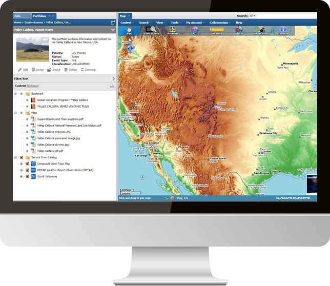
WES 14 is based upon best-in-class open-source geospatial tools and technologies, combined with the incorporation of international standards, to provide users with the ability to store/catalog, create and deliver geospatial information and content. It ultimately provides users with situational awareness to support the decision-making process, and access to and analysis of geospatial, scientific and technical information and content utilizing standard WES interfaces as well as providing integration capabilities via web APIs.
 

Responsive Image

Open-Source Software Capabilities

WES incorporates many open-source capabilities for geospatial functionality. Examples include the following:

Responsive Image

Liferay

An open-source enterprise portal used to provide a Java-based web application platform that provides a toolset for the development of customizable portals and websites. It is one of the most popular CMSes in the market for managing and administering website content and provides a wealth of collaboration tools.
Responsive Image

QGIS

This open-source application is provided for those organizations that need to create, edit and/or update geospatial datasets. When distributed with WES, it incorporates “plug-ins” that enable users to search, discover and publish data created by QGIS into the WES back-end databases and catalogs. It also contains a plug-in that facilitates the ability to use the OGC Web Processing Service (WPS) for “wizard-like”, chained geospatial processing for on-demand creation of new products that are made accessible within the application.
Responsive Image

Apache Solr/Lucene

An open-source, full featured NoSQL database engine that is used within WES to provide a full context metadata repository of all information contained within the repositories and provides an “Amazon-like” interface for flexible, faceted searching etc.
Responsive Image

GeoServer 

WES uses this open-source geospatial data server that has been designed for interoperability and excels at publishing major spatial data sources using open standards.
Responsive Image

PostgreSQL

An open-source database that is used as the default relational database for WES and comes pre-configured and ready for operation when installed by the WES Installer.
Responsive Image

GeoNetwork

This open-source application provides WES with metadata editing capabilities.
Responsive Image

Geospatial Data Abstraction Library (GDAL)

This open-source application is used within WES when translation of geospatial data is required for either incoming (i.e., data loading) or outgoing (i.e., data delivery).
Responsive Image

PostGIS 

An open-source add-on to support the use of geographic objects when using the PostgreSQL object-relational database.
Responsive Image

CesiumJS

An open-source JavaScript library for creating world-class 3D globes and maps with the best possible performance, precision, visual quality and ease of use.
Responsive Image

Tirex 

A suite of programs for running a tile server that was developed for OpenStreetMap tile servers but is used by Compusult used for generation of raster maps as well.
Responsive Image

Mapnik 

An open-source mapping toolkit for desktop and server-based map rendering.
Responsive Image

mod_tile

A custom Apache module that is responsible for serving tiles and requests the rendering of tiles. It provides a dynamic combination of efficient caching and on-the-fly rendering.
Responsive Image

Leaflet

An open-source JavaScript library for mobile-friendly interactive maps, used for building web mapping applications.
Responsive Image

Apache Tomcat

An open-source implementation that provides a pure Java HTTP web server in which Java code can run.
Responsive Image

Apache httpd

The Apache daemon server that processes all Apache Web Server requests.

Responsive Image

Basemap and Backdrop Geospatial Datasets include:

  • A unique Open Topo world coverage composed of OSM vector, ASTER imagery GDEM and SRTM imagery DEM. This data set is available in ArcGIS tile package (.tpkx) and Tirex and Mapnik was used to generate the tiles. The mod_tile Apache 2 module was used to make the tiles available as an OGC WMTS.
  • Open Street Map (OSM) by downloading OSM data and making it available in ArcGIS tile package (.tpkx) and Tirex and Mapnik was used to generate the tiles. The mod_tile Apache 2 module was used to make the tiles available as an OGC WMTS.
  • SRTM world coverage by obtaining the SRTM imagery and creating mosaics for world coverage that is available in ArcGIS mosaic dataset format and Tirex and Mapnik was used to generate the tiles. The mod_tile Apache 2 module was used to make the tiles available as an OGC WMTS.
  • LANDSAT 8 world coverage by obtaining the Landsat 8 imagery and creating mosaics for world coverage that is available in ArcGIS mosaic dataset and Tirex and Mapnik was used to generate the tiles. The mod_tile Apache 2 module was used to make the tiles available as an OGC WMTS.
  • Sentinel 2 world coverage by obtaining the Sentinel 2 imagery and creating mosaics for world coverage that are available in ArcGIS mosaic dataset and Tirex and Mapnik was used to generate the tiles. The mod_tile Apache 2 module was used to make the tiles available as an OGC WMTS.

Supplemental Datasets
Available Through OGC API Interfaces

The application also contains:

  • Daily Polar Sea Ice and Iceberg Concentrations – Automatically obtained and downloaded/processed on a daily basis. Also available historically, if required.
  • NOAA General Regularly-distributed Information in Binary form (GRIB) - Automatically downloaded and processed every six hours and presented using OGC Coverages API. This allows users to interact with temperature, precipitation, cloud cover, wind speed/direction, humidity, etc. on a global scale.
  • NOAA METAR Airport Weather Report Observations - Automatically downloaded and processed every hour and provided using a variety of OGC services/APIs.
  • Federal Aviation Administration (FAA) Commercial Air Traffic and Live Flight Information - Automatically downloaded and processed every hour and provided using a variety of OGC services/APIs. Requires special licensing.
  • Automatic Identification System (AIS) Maritime Ship Traffic - Automatically downloaded and processed every hour and provided using a variety of OGC services/APIs. This data is obtained via AISHub. Requires special licensing.
  • NOAA National Data Buoy Center (NDBC) Buoys and Ships Observation Data - Automatically downloaded and processed every hour and provided using a variety of OGC services/APIs.
Responsive Image

Request a Live Demo

Access our demo site to use a sandbox version of WES.

Please submit a request for a live demo